Thursday 14 December 2017

What Do You Need for a Smart Geological Exploration?


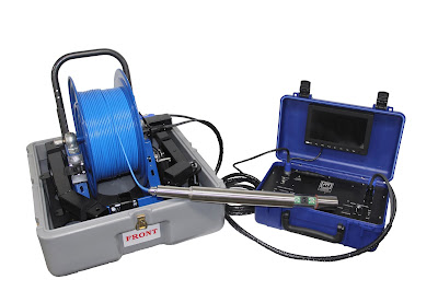
When you are looking to delve deeper and understand the subsurface geology, you need the perfect gear for a smart exploration. Look for a comprehensive geological modeling and interpretation solution that serves your needs. For measuring dry density, you need borehole density probe and a system compatible with these logging probes. 

Choosing a Logging Probe:


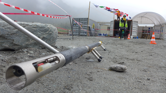
The specifications required by a logging probe may vary on various parameters. A density probe is used for applications like measuring petrophysical properties, density porosity, coal quality, coal delineation, and quantitative in-situ density. When selecting these probes, you need to follow the standards required for the specifications. Usually, these probes have a collimated density detector housing and a single caliper arm. They are mostly integrated with sodium iodide detectors. You should choose the right specifications as per the requirements of your exploration. The differences in these specs can cause deviations in the data sets generated by the geologists. 


Choosing a Compatible Computer System:


You should prefer a rental fully-configured computer system that is pre-installed with borehole logging software. This system should be configured to the recommended settings and have tool configuration files installed on it. Moreover, it should be tested for compatibility with your logging equipment using configured files and systems. The software installed on it should allow conversion of data into accurate geological models and section maps. It should provide multidisciplinary data for accuracy in your operations. 

Preferably, you should choose a reliable company for renting this specialized equipment for a smart geological exploration. 

Thursday 16 November 2017

3 Keys Benefits Of Using An Efficient Petrophysical Software

Petrophysical software

Petrophysics studies the properties of the rocks and fluids that exist beneath the earth’s surface. It plays a crucial role in exploration and extraction of oil and gas. The petroleum reserves could lie anywhere from a few hundred metres to 2-3 kilometres in the earth. This industry involves high cost, high labour and intelligent operations.

The introduction of petrophysical software has proved to be a turning point in the petrophysical industry. The innovative solutions have helped geoscientists and reservoir engineers understand the rock properties of the reservoir. It helps collect and analyse information on the lithology, porosity, water saturation, permeability and density of the rocks.

Here are three key benefits of using petrophysical software:

1. Saves costs and time – Before the advent of petrophysical software, the data was collected and recorded manually. Also a lot of time was lost from the data collection to data interpretation. Since the petrophysical software gives you detailed digital data with little manual intervention, a lot of time and also costs are saved.

2. Interactive data display – The software has an interactive user interface making viewing, editing and analysing data quick and hassle-free. The data is represented using graphs, charts, tables, curves, pie-charts etc.

3. Aids reporting and analysis – Traditionally the reports were largely manually made. Certain portions of the data, required for reporting and presentations only were graphically presented. You get the data real-time as well as historic records making it possible for quicker and more detailed analysis. 

Tuesday 24 October 2017

Need For Borehole Logging Technology for Different Types of Logging

Borehole logging is extremely important in the mining, engineering and environmental industry for doing a detailed study of the geological formations occurring beneath the earth’s surface. With the advancement of technology the way the logging is conducted has changed. The equipment has become more mechanised, the software has enabled digital logging.

This new technology can aid the measurement process of different types of logs:

1. Electrical logs – Electrical logs mainly include resistivity log and borehole imaging. The subsurface ability to hinder flow of electric current is measured under resistivity logging. It helps identify the presence of hydrocarbons since the parts of the subsurface with salty water are a good conductor of electricity while the hydrocarbons are bad conductors.  Under borehole imaging uses centimetre-scale images of the borehole. It reveals detailed data on reservoir performance, fractures, breakouts, sedimentological features.

2. Porosity logs – Porosity logs measure the percentage of pores in the rock. It includes density logging, neutron porosity and sonic logging. Density probe is used to measure the bulk density of underground formations following radioactive bombarding. Similarly, neutron porosity is measured by bombarding formations with high energy epithermal neutrons. The sonic log uses the time taken for sound waves to travel to measure lithology and rock texture.

3. Lithology logs – Gamma ray logging and spontaneous potential logging are lithological logs. The gamma ray helps identify the presence of radioactive material in the different types of rock formation. The SP method measures the difference in the electrochemical potential between the borehole and surface.

Wednesday 20 September 2017

How Borehole Logging Can Help Efficient Project Management

Geoscience industries like construction of highways, environmental applications, research and mining for minerals, oils, gas are generally capital-intensive. They require a massive investment in machinery and tools, labour, regulatory procedure etc. Whether it’s a government project or managed by a private entity, the aim is always to achieve maximum possible output at the minimum possible cost without compromising on quality.

Borehole logging

Here is how borehole logging can help in efficient geoscience project management: 

1) High level of productivity: Productivity in the geotechnical and geophysical industry would mean completing more work in the standard time. The borehole logging helps you discover the subsurface properties like nature of the rocks, the different geological layers, availability of underground water, existence of any radioactive materials, etc. The logs will helps you plan and manage the process better.

2) Good quality output:  The results of the borehole logging will give you a fair idea of what you could discover after excavation and also the nature of the subsurface. That will help you do a cost-benefit analysis and understand whether the exploration is even feasible or not. This way you are more likely to uncover better quality of output and you can also better plan for the processing stages.

3) Control on costs: The borehole logs help in efficient project planning. This means lower hours are lost due to unexpected situations. You would also save the costs you would incur in exploring an unfavourable area. The borehole tools can be bought or rented depending on the nature of the project and duration.

Tuesday 22 August 2017

Six Reasons that Justify Undertaking Borehole Logging

When you need to accumulate data about a particular area’s sub-surface, you instantly think to gather it with surface methods or sampling. However, these are not always applicable in all cases. Whether you are to plan and map out the perfect position for water well or wish to undertake subsurface investigations; maintaining a borehole log is deemed the ideal solution. 

Well logging

This write-up elucidates the many perks of borehole logging.

1. It offers you a stream of data perpetually as opposed to opting for a sampling method that could be somewhat unreliable.
2. It ensures that you can check the dimensions in situ. In fact you can even take measurement over a period of time at regular intervals to spot any variations or differences.
3. You can proceed to conduct a comprehensive analysis of gathered data both vertically and horizontally from the boreholes.
4. It makes a worthy addition to the existing findings by notable geologists as well as the records created by on-site drillers.
5. This is often deemed an integral part of geotechnical initiatives in addition to environment projects and related exploration initiatives.
6. A lot of experts suggest borehole logging as the ideal way to collect information when all other methods of attaining data fail. 

If your team must undertake borehole logging on your next project, you may want to lease or source the right equipment for the job. However, do remember to do so after conducting extensive research on the manufacturers or distributers to make a safe purchase.